google, short and sweet

Two google fanboy posts in one day! Still, they’re worth it 🙂

Google have just made their short URL generating service available through a public web interface. This is not that earth shattering, I’ve been using the service via the chrome extension and it’s worked well for some time now.

However, the excitement starts if you’re logged in to your google account, when it will present you a nice little history of your created URLs with click counts, and basic reporting, but the feature I love is the auto generated QR code!

you don’t even need to be logged in to access this information, they have created a neat URL based way of accessing it, so for this short URL:
http://goo.gl/DsH0
there is an information page:
http://goo.gl/info/DsH0
and a direct link to the QR code:
http://goo.gl/DsH0.qr

Not only that, but the API for the QR code generator appears to be open and usable by anyone who generates the request URL!

about 100 metres…

For me, one of the high points of Australian television entertainment was The Games, and one of the high points of that series was episode 4, series 1, Robbo and the 100 metres. Even reading the script cracks me up (the particular scene starts around page 5), but at the risk of providing a spoiler to those who haven’t come across it before, the premise of the episode centers around a 100 metre track that is about 100 metres… well, 94 metres to be exact. It’s just too ludicrous to be real, which is why it’s so side-splittingly funny.

JOHN: But what you’re telling me is the 100-metre track is about 100 metres long.

Too ludicrous? well, you would have thought so, that is, until last weekend when they held the Melbourne marathon. Seems like the Marathon and Half Marathon were the prescribed distance, but someone played fast and loose with accuracy when it came to the 5km. and 10km. events, but to quote Dallas O’Brien, the event director: the 5km and 10km courses were not measured to the same exacting standards“, and “perhaps we should have highlighted the fact that they weren’t 100 per cent accurate”.

Not 100% ? How about 84% ?? because that would have been about right, yes the 5km. route was only 4.2km! Now, most runners are pretty aware of how fast and far they’ve run – these things tend to be important. Many carry personal GPS devices and can tell you within a few metres just how far they’ve run. Pity the organisers didn’t apply the same rigour: “The five and 10 were both measured by a bike computer. We got them as close as we could.”. This is, of course, complete rubbish and a totally lame excuse. It took me no more than 5 minutes with Google maps to trace the route and get exactly the same answer as the runners got. The 10km route was not quite so far off – but at 9.4km (exactly the same percentage error as the fictional 100m track), you can bet it got some people excited about personal best times before the true horror dawned on them.

A little message for Mr. O’Brien, either get a new battery for that bike computer, or pump up the tyres, but don’t, in future, take people for idiots… did you think they wouldn’t notice?

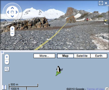
google street view car in austria

Yes, on a recent holiday in beautiful Austria, the nerd in me became very excited to see in the right lane of the motorway up ahead a little red Opel with a big black camera on top.
Google Street View car in Austria
Yep, streetview is definitely on the way to Austria and I’m hoping there’ll be a photo of me taking this photo. Such nerdery!

Published
Categorized as geo

the other street view

…there’s another one? I hear you gasp! Yes, it seems the old one about imitation being the sincerest form of flattery has struck a chord at streetdirectory.com.au – and they obviously love Google!

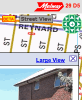
street view in brunswickThis is sort of amazing to me – I mean it’s incredible enough that a giant corporation like google pushes forward with a program of driving a car down every little lane and street in town and then stitching together the visuals, now we’ve got our own home-grown version!

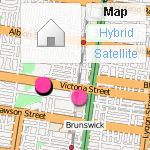
Try it out at this intersection in Brunswick. Wierdly, that link, which I copied from the ‘send a link’ tool on their site, ends up displaying a street 300m to the north, so there’s obviously a bug or two there, but ignore that and start counting the similarities.

  • For a start, it’s called “Street View” – I’m sure the big G will have something to say about that.
  • You can tell which streets have the imagery by the blue purple outline.
  • How cute, they’ve got a little yellow man on a green arrow the you can drag and drop on aforementioned outlined streets. Where have I seen that before?
  • There are similar navigation tools to Google’s, but they’re terribly ugly and as soon as you try to drag an image around, you’ll see that they don’t work like Google’s – they really don’t work at all! (browser hangs… doh!)
  • On the positive side, the images are much higher resolution than you get in Google. The ‘large view’ shows it off very nicely. On the flipside, the bigger images completely break the experience of ‘moving’ along a street as each image takes it’s sweet time to refresh.
  • Just like Google, faces are blurry, but unlike Google, it’s obviously been done manually, by someone with photoshop and a blur tool
  • There’s a little ‘BETA’ tag to let us know that this software might have some bugs – well, they got that right!

OK, so I’m a big fan of the Melways street directory: it’s a great publication and I’ve worn out more copies than I can remember – they draw great maps. Due to peculiarities of projection, it’s never translated comfortably to the online version, but this latest venture just seems preposterous – especially when it’s been released with so many shortcomings. Isn’t there some business rule about playing to your strengths?

Published
Categorized as geo, tech

Flickr’s open (street) map

osm flickr layerI don’t know when this happened, but last night when I placed some photos on my flickr map, I was delighted to see that (in certain areas, and at certain magnifications) they have started to use OpenStreetMap for the map layer.
Yahoo were generous enough to allow OSM to use their satellite data as a reference overlay for constructing maps, so I think this is a natural flipside of that. Personally, I think it’s great that I can place photos on a map that I also contribute to. Three cheers for open source!

Published
Categorized as geo, tech

now THIS is a bike path!

… but what are all those cars doing on it?

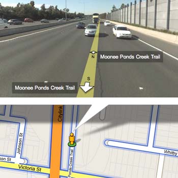
According to Google Maps ‘blue outlined streets’ have Street View, so I was surprised to see that they must have left the car behind one day and hopped on a bicycle, because the Moonee Ponds Creek bicycle trail was outlined in blue just near my house. Alas, the Street View pics don’t give a true representation of the bike path – it seems wider and busier than I remember it.

The Moonee Ponds Creek Tollway

Uh-oh! algorithm troubles! That looks very much like the nearby tulla freeway. I’m sure we’re going to see a lot more interesting anomolies among the new Australian images.

where was their spirit of adventure?

One of the fascinating things about Google’s Street View coverage of Australia is the amazingly out of the way places they got to. I love this aspect – dirt roads that wind along in the back blocks of the never never.

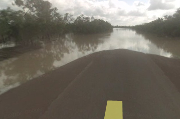
Anyway, I was panning around the Gulf Country of far north Queensland when I noticed the blue line didn’t go all the way to Normanton. Odd – so I dropped the little yellow guy as close as I could to the end of the line and saw in the distance what looked like… yes, I think it is… water! Ha! that’s the Gulf Country for you.

Burke development road

No wonder they never got to Normanton 🙂

Domain – first to market with Street View?

Checking my moderation queue, and noticed a comment on yesterday’s street view post, that seems to be from someone on the Domain team. I didn’t see the comment until this morning, but I did receive an announcement email from Domain yesterday and was mightily impressed with their use of streetview.

Obviously, they’ve had access to the service for a little while now and have implemented a slick tab method of switching between street view and map view. In fact, I think it’s better, or at least more intuitive than the default ‘balloon’ that most google maps use.

With this release, Australians are entering a whole new dimension of real estate and travel. Without even thinking about it, I have already checked out a hotel I am hoping to book in Adelaide (confirmed easy access to the Torrens and gardens), I also poked around a couple of interesting properties in Fitzroy ad noted that while the real estate pages mention nothing about graffiti, the street view shot clearly shows that the property is regarded as a bit of a ‘canvas’ by locals.

What I can’t quite fathom about Street View in Australia, is the incredible coverage. I can understand the Google investment in cities and tourism areas – there’s an obvious commercial return there, but I am completely puzzled (and delighted) that they seem to have driven from Jamieson up the Woods Point road to Gaffney’s Creek! That’s impressive!

I’m sure we’re going to hear a lot about this in the coming weeks. My congratulations to the team at Google for such an impressive launch and also to Domain for an excellent commercial implementation. Go check it out!

Street view invades Australia

I can’t wait for the conspiracy theorists to get going on this one – Google have released Street View on their maps in Australia. Unlike earlier releases, this is a massive and dense coverage… amazing detail.

The face blurring technology is in full swing, and not very discriminate – blurring both the wheels on my car, as well as heaps of other vaguely face like things.

Anyway, I’m pleased I wasn’t imagining things when I spotted the Google car last March.

make your maps open maps

This week Google announced (yet) another new feature of it’s mapping toolset. For a little while now, we’ve been able to ‘submit’ alterations via the maps interface – moving things here and there – a quick look at Google Maps Recent Edits shows that it’s quite popular. The latest thing is Map Maker, which is a bit like My Maps, except your edits may eventually find their way into the public maps.

Nice idea, but if you have a close look, you don’t get a lot for your efforts. Pan around google maps and you’ll see the copyright message in the lower corner that attributes the data source of the various providers, but don’t expect to see your name there any time soon… no, if you submit data via mapmaker (assuming you are in one of the areas currently open), that’s the last you’ll see of that little piece of intellectual property. Furthermore, if your edits ever do make it to the public maps, they’ll be under the same restrictions as all the commercial data. Google might be touting this as some kind of community effort, but it aint.

Contrast their approach with that of Open Street Map: an active supportive community; great editing tools; open to anyone; your edits appear on the main map within a week; infinite detail; the list goes on. Sure OSM doesn’t yet have the detail of Google in all areas, but where the community is active and strong, the data is way better than Google’s.

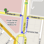
Google’s wayward sense of direction.Just around the corner from my work is an example. The Elizabeth Street roundabout is one of the busiest intersections in Melbourne. It’s daunting enough for locals, but if you’re from out of town, it would help to have a good map. Superficially, OSM and Google are similar, but if you look closely you start to see the problems:

  • For a start, the Dental Hospital hasn’t been there for about 10 years. The building is derelict. OSM knows where it is now.
  • According to Google, it looks like Grattan street doesn’t make it all the way across Royal Parade, which Google thinks is the Hume Highway… hmm!
  • and what is it with the way all the service lanes join the roads as they approach the roundabout on Google? I can assure you – this is fantasy.
  • OSM aso seems to know what it’s doing with one way streets – something Google has real trouble with. Maybe they don’t know we drive on the left in Australia, but my colleague big ben pointed out the other day that following Google’s directions from one part of Grattan Street to another will get you into a lot of trouble!

Anyway, the point of this is not to bag Google maps – they are fantastic, they have popularised digital mapping and changed the way we get from one place to another… but, they are still a company and you we still rely on them to provide the service and the tools to go with it. OSM on the other hand is open source – the data is there for everyone to use – tools can be created, crafted, improved and distributed without messy licencing. Wikipedia was recently shown to be every bit as comprehensive and accurate as the venerable Encyclopaedia Britannica and so it will be with OSM. It will be the mapping tool by which all others are judged. So if you’re thinking of making maps – do it the open way!

Published
Categorized as geo, tech

False start for China?

All eyes on China at the moment – they must have expected that, but what the world wanted to see was a new approach. Awarding the Olympics is defended as an incentive – a carrot, if you like – to lure China away from it’s old ways. Sadly, it looks like that’s not gonna happen. A few interesting events this week to illustrate the problem.

Tibet: it’s a tricky issue and I won’t pretend it’s a simple right and wrong, but if the Chinese want Tibetans to feel like part of China, then they’ll need to start treating them as equals. It’s never been that way, and recent events indicate, it’s not going to be that way any time soon. A bunch of foreign journalists are led on a tightly controlled tour of Lhasa, but the tour gets out of control and a few, incredibly brave monks mob the journalists and attempt to get their side of the story heard. Reports on Xinhua, put their own spin on the event, but the most telling piece of commentary is a story that has China’s foreign ministry condemning the western news services for ‘distorting’ the news and applauding an anti-cnn website as a “reflection of the chinese people’s condemnation”… which people? certainly not the monks. Ironic stuff.

Olympics: no point saying they shouldn’t have got the games – it was done and dusted years ago. Totally unfair to all involved to talk of boycotts; athletes have given up years of their lives in preparation for this, they shouldn’t be asked to make a political statement when it was the politicians’ mistake in the first place. The athletes never chose Beijing. Heartening to see the approach of the Czech and Polish leaders, boycotting the Opening ceremony is the perfect way to deliver the snub that would sting China’s leadership most. A loss of face. The French president is considering the same.

and finally Maps: another report from Xinhua, so you can be assured that the point of view is strictly pro government, however it shouldn’t alter the facts… apparently: “10,000 online map websites operated in China, most of them showing maps without approval”… that’s right, maps without approval! “A hotline has been set up for the public to report illegal websites” – the walls have ears – and “those websites would be closed down”. My favourite quote:

“The campaign would also target websites that made mistakes such as labeling Taiwan a “country”, wrongly drawing national boundaries, or omitting important islands including the South China Islands, Diaoyu Islands and Chiwei Island”

The only site that seems to have the official blessing is the State Bureau of Surveying and Mapping (SBSM), which has a whopping 418 Chinese and world maps, that obviously give the Chinese people all the information they’re ever going to be allowed to need.