This map is open to the public

Regulars will know of my weakness for anything to do with maps. Some time ago, this manifested itself in the purchase of a Garmin eTrex Legend Cx. This device is brilliant, perfect for my needs… walking, riding or driving, and after a few hiccups I got it talking to my mac. The only thing I’ve never done is purchased a map.

Garmin charge a pack for their maps, and I’m sure they’re very good – especially for route finding and driving, but for my needs they are overkill in the city and not much good in the bush. So, I was on the lookout for alternatives.

google censorship, national security & pepsi

Like most google map watchers, I’ve heard the debates about censorship on Google Maps. Pressure from governments, back room deals, conspiracy theories… it all gets a good workout on the forums, lists and blogs. Until now, the common theme has always been national security… mostly defence installations.
Pepsi HeadquartersNow, it seems that money buys you anonymity. Or maybe Pepsi is really just a front for a chemical weapons factory… whatever, the reason, there is a neat square of blurred imagery (looks like photoshop’s ‘pallete knife’ is the filter of choice) in among photos of excellent quality, and that square obscures the headquarters of PepsiCo. Draw your own conclusions.

Google finally embeds My Maps

Like every other Google map geek in the world, I’ve been waiting with anticipation for the release of embedded ‘My Maps’. Most unusual for Google to announce a feature before it’s released, usually it’s just a matter of keeping an eye on the blogs or looking for the “New” at the top of the various Google services. This time, however, the news was out more than a week ago, so I’ve been checking daily to see what form the new feature would take. Finally, it’s here with lots of good points and a couple of bad ones.

Published
Categorized as geo, tech

Google is the new axis of evil

The Fairfax created “Brisbane Times” site blares out Terrorists also find Google useful, obviously this google maps thing is a threat to all of us! Presumably the terrorists also found computers rather useful – oh, and the internet! and probably Microsoft’s operating system… yep, we should ban the lot of them.

Alternatively, perhaps we could look at treating the cause of these problems rather than patching over the symptoms… nah! way too hard.

So, how did Google do it?

Well, the fact is, they didn’t – entirely. Sure, it appears in Google’s wonderful maps, but the images were captured by a company called Immersive Media, who have developed these innovative products.

Immersive Media's wonder carIt seems that Immersive’s main thrust is moving images – spherical video with embedded geodata – very impressive stuff. In typical Google fashion, however, they’ve released a lo-fi version that really hits the spot. Other blogs have pointed out that the flash player used by google references individual tiles and stitches them together on the fly – very clever stuff.

Immersive say they’ve been taking these photos since 2005. I don’t know what the schedule was, but there is ample evidence of an improvement in the technology over time – the more recent images are substantially higher resolution – compare a New York shot at full zoom with one from San Francisco.

Further evidence of a time lag can be found by comparing the racy little VW with the groovy little camera – which you can occasionally catch a shadow of, with the shadow of a much less streamlined version.

All interesting enough – but really, we know it’s just damn good fun!

newly found – great close up of the van, and a blog post about google van self portraits too!.

Published
Categorized as geo, tech

google maps street view – amazing

When I first used google maps I was utterly speechless at the smooth way they could present the incredible amount of data that the system held. Well, they’ve done it again – in spades!

There are plenty of blog posts talking about it, but the instructions found at googlemapsmania are simple and easy:

head over to Google Maps, center the map on the US and click “Street View”. Click a city with a camera marker and zoom in to have a play.

Once you’re there, click anywhere on a blue outlined street and suspend all disbelief… this is a ‘virtual tour’ on a scale no-one has even dared dream about. For a quick way in, try this view of the Golden Gate Bay bridge (thanks Jeff), which Product Manager, Stephen Chau rates as his favourite.

The big question is HOW? This is a lot of work, in anyone’s language, so how have they done it? Not hard to see that the images are taken in sequence, about 25m apart, and there are reflections that suggest some sort of plastic bubble – probably mounted on top of a car. I would have expected this to be done with a one-shot pano camera, but some images show signs of being stitched (though maybe it’s those reflections again). I’m assuming they are located using geocodes, so that’s probably automated into the exif data… incredible stuff!

Another aspect which should not be overlooked, is that the ‘Link to this page’ link works as you’d hope (better than you’d expect!). It takes you to the map, the location, the view and the zoom level – all in one hit. Business is going to love this!

Just imagine what implications this has if they release some API hooks for the pano viewer!

Published
Categorized as geo, tech

my maps are google maps

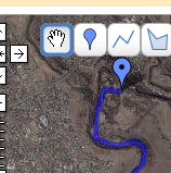
brimbank-gmap1Google’s most revolutionary tool, Google Maps, has just added a new feature – My Maps – which brings ‘mapping’ to the masses.

It is brilliant. You can create maps, draw shapes, make points, add html features such as photos. Sure, there are dozens of tools out there already which allow similar capabilities, but Google, in typical style, have created the basic flexible framework which will see the widespread adoption to make it mainstream. And… the really neat part for me is the ‘KML’ link, which downloads a kml file for Google Earth.

What’s so good about that? You can do all the drawing and mapping in GE, but you can’t manage a web repository of your files – that’s the beauty of ‘My Maps’.

Once I have my KML file I can use GPSBabel to convert it to GPX and upload it to my Garmin eTrex. So, effectively, ‘My Maps’ is now my web based respository of GPS data!

To give it a road test, yesterday I mapped out the route from Maribyrnong park to Brimbank park along the Maribyrnong River. This ride is part of Bicycle Victoria’s ‘Bike path discovery’ program, but you don’t need an excuse to ride it – it is a beautiful track. Anyway, the mapping worked perfectly – I was a happy (and tired) cyclist by the end of the day.

Wishlist: I won’t consider it perfect until I can import kml or gpx I’ve created elsewhere. As it matures, I’d also like to see fuller support for GPX, such as perserving icons etc. but that’s secondary.

Recommendation: get out there and start mapping – I think we’re about to see mapping and mashups go seriously mainstream!

I can even view my flickr stream as GeoRSS in Google maps!
Published
Categorized as geo, tech

sydney under the microscope

It’s just over a month since Google made their much publicised flyover of Sydney for Australia Day, but I’ve just received the email to let me know it’s all gone live! It’s huge! the resolution is eye popping. I’ve yet to have much of a look around, but the email from google included the following locations to get me started; Queenscliff Bay, Shark Bay, Bondi Beach, Manly Beach, Luna Park, North Bondi, Helicopter, Tall Ship, Fort Denison and Circular Quay.

Not a bad selection, but I’m sure we’re about to see a flurry of interesting sightings over the next few weeks. I noticed that the famous swimming pool at the south end of Bondi Beach seems to have suffered a major earthquake, but I’m yet to spot any ‘events’ where people have gathered to get noticed on google maps, though this was a major thrust of the publicity.

At first glance, if I was at google, I think I’d be a bit disappointed. The coverage appears to be pretty patchy and has caused them a fair few splicing problems. Also, is it just me, or are the shots a bit over exposed? I was expecting the boats around the Opera house to be great sights, but they are mostly bleached out. Anyway, it’ll be interesting to see how the community reacts. Are they going to ‘do’ Melbourne next?

updates

You’d be a bit pissed off if this was you. Spending the time and effort to get a huge sign out there where the google plane would see it only to have the light fall on it in such a way as to make it illegible.

Published
Categorized as geo

geotagging workflow for mac users

It’s not always easy using a Mac. Being in the minority means you don’t have access to many of the tools others take for granted. GPS is a good example. I love my little Garmin eTrex, but Garmin don’t love my mac. They have promised software this year, but details are very sketchy. So, I live hope, but in the meantime, I’ve got things I want to do, like geocoding the 2,000 odd photos I took on a recent holiday to Thailand and Myanmar!

Published
Categorized as geo, tech

The KFC face from space

Michael Castellon writes about the KFC stunt that saw them launch a new logo by building one big enough to be seen from space.

Actually, being seen from space is almost certainly not their concern – space has a relatively sparse population and probably few of them visit KFC stores.

What they’re really hoping for is to be included in the satellite imagery of one of the big mapping tools.

At the moment, Google’s imagery of the area is only low res now high res and the logo is there!, but both Yahoo and Microsoft have got the jump and already have high res of the area. All three maps correctly identify the area as ‘Rachel, Nevada’, and the location as the corner of Groom Road and Old Mill Street – just off “The Extraterrestrial Highway”!

Published
Categorized as geo

China is our friend…

Lucky really, with the Olympics and all, China is really becoming part of the world community. I’m glad they no longer seem as willing to expand their borders through military means. Hang on a minute, what’s this?

Aksai Chin is a region between India and China and is one of the main areas of dispute between the two countries. This hasn’t spilled over into significant action since 1962, but recently a German Google Earth user ‘KenGrok’ spotted an amazing scale model of the region tucked away in what looks like a military base in northern China.

Most agree, it’s unlikely to be related to any direct military plans, but it’s sure unsettling, and great fodder for the conspiracy theorists.

Check out this Google Earth (kmz) I’ve created which overlays the two areas for (startling) comparison.

Now, I wonder where their scale models of Taiwan are 🙂

Published
Categorized as geo

Round-tripping geocodes from Flickr to Google Maps

I love Flickr. I love Google Maps. Like a lot of people, I’d like to combine my love for these two tools by accurately geocoding my photos and then being able to see where geocoded photos were actually taken. I was frustrated that all the tools to do this either required GPS equipped devices, or clunky and less than intuitive interfaces.

I also like bookmarklets. Little bits of JavaScript code that you can just click on to do things. So, I created these two bookmarklets that allow ’round-tripping’ of geocodes to and from Flickr and Google Maps. Hope you like them!

Published
Categorized as geo, tech