… but what are all those cars doing on it?
According to Google Maps ‘blue outlined streets’ have Street View, so I was surprised to see that they must have left the car behind one day and hopped on a bicycle, because the Moonee Ponds Creek bicycle trail was outlined in blue just near my house. Alas, the Street View pics don’t give a true representation of the bike path – it seems wider and busier than I remember it.
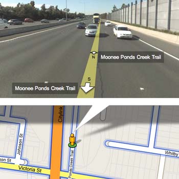
Uh-oh! algorithm troubles! That looks very much like the nearby tulla freeway. I’m sure we’re going to see a lot more interesting anomolies among the new Australian images.
The trail runs right along the base of the other side of that wall on the right of the photo, about four metres below the road level. So the line is probably 5 or so metres off the actual trail. Ride it two or three times a week.