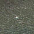
 There is still relatively little high res imagery of Australia, there’s even less that covers major airports and regional airports… well, they’re hard to find. All the same, it’s a bit disappointing when the US has so many planes in flight, that I could only find this one, just off Point Cook, Victoria. We actually go for picnics right nearby – it’s a beautiful spot with dozens of species of migratory wading birds… and there’s always a plane or two coming and going.
Category: geo
birth pains of a nation…
 Of course, I’m still finding interesting things on google maps, but every now and then you stumble across something that is more than just an image. You see, the high-res photos on google are (we’re told) up to 3 years old, the medium res ones are probably more… they are little snapshots of history.
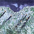
On May 20, 2002, Indonesia relinquished control of East Timor, finally putting paid to years of brutal repression. It seems ages ago now, and although a few Australians remain in support roles, the horror is a fading memory. This image of palls of black smoke rising from several locations in the capital, Dili, looms up from google maps as a stark reminder of those terrible times.
amazing google sights…
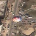 Yeah, I’m still hooked on Google maps, so I’m going to risk boring you with a few more great spots to visit. First, there’s this hot air balloon over Berlin. Then there are some enormous fires in Siberia. Finally – it’s virtually impossible to spot individual people on these maps, but a crowd is pretty clear. So far, I’ve only see sporting crowds, but here is a clearly visible crowd on a Barcelona beach. Nice!
the ‘mighty’ snowy…
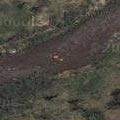 OK, next to the world’s big rivers it’s just a trickle, but it’s our trickle! The Snowy River flows from the highest mountains in the country down to the sea near Orbost.
With all the controversy about river levels and ‘environmental’ flows, it’s heartening to see that, at least when this picture was taken, it’s got a healthy flow. Judging by the colour of the water, I’m guessing it’s recently rained. In fact, the flow is so healthy that I’m sure we can see a white water rafting trip in progress! Definitely a couple of rectangular orange blobs with another one about 100m upstream. Lucky them, eh?
pyramids
 There’s something a bit circular about looking at an ancient relic like the Great Pyramid of Gizeh through the magic of a technology as new as this.
we’ve got high res!
Yippee!!… Google Maps have gone global – there are patches of high res photography scattered all over Australia and other non-US bits! So, much as I love (and will continue to patronise) googlesightseeing, I want to start my own archive of great locations. Australia-centric, but not exclusive.
Just to kick it off, I’m starting with the main intersection on my street – because I can! Future links will be much more exciting – I promise!!
that eye in the sky
I admit it, I’m a bit of a map nerd… I just love ’em – the more detail the better. You can learn a lot about a place just by looking at a map. You can learn even more by looking at an aerial photograph, and google maps has got lots of them! So far, the high res images are only in the more populous areas of North America, but striking images can be found over the whole of the continent. In fact, it’s a bit addictive – a bit of a time waster!
If you can’t be bothered with trawling through masses of photos and just want the juicy bits, check out Google Sightseeing, a winderful blog with daily updates of cool things that can be found on google maps. I’ve even had one of my submissions shown!
Oh, and before I go, here are a few of my favourites: the boneyard, the grassy knoll, the hollywood sign and Yazgur’s farm. Cool, eh?