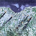
 Of course, I’m still finding interesting things on google maps, but every now and then you stumble across something that is more than just an image. You see, the high-res photos on google are (we’re told) up to 3 years old, the medium res ones are probably more… they are little snapshots of history.
On May 20, 2002, Indonesia relinquished control of East Timor, finally putting paid to years of brutal repression. It seems ages ago now, and although a few Australians remain in support roles, the horror is a fading memory. This image of palls of black smoke rising from several locations in the capital, Dili, looms up from google maps as a stark reminder of those terrible times.
Did you notice that Google Maps doesn’t have East Timor’s boundaries in their maps data yet?